In 2005 I posted my photos and discussion of the Richard Mine at Mt. Hope Park of Morris County NJ. Since then I've had some correspondence with those who had relatives who worked them mine, and even some former miners. With their permission, I've put that material here on this Web page.
Anyone with more info about the Richard Mine and its miners in the early 20th century can write to me, and I'll post some of that here. - Herb Johnson - Herb Johnson
Early in 2009, I saw that a museum not far from the Richard Mine, the Morris Museum, was going to have a talk given by Dan Lopez about several abandoned mine sites and his explorations. Dan has a Web site, abandonedmines.net, which shows some of his work, and which has a discussion forum for those interested. Here's a bit of our correspondence. - Herb
Hi Mr. Johnson,
I'm glad you enjoyed [my Web] site, I started this in 2004 and I am so surprised and excited at how its grown. Its people like you that we love to have to discuss and learn from each other. We have a forum I would love if you joined, we all talk about mines, history and other things. We're an open group and looking to meet and grow.
I saw your links, I have visited the mining site but never really posted up about Mount Hope. I know the area pretty well.. I have a few photos of the New Leonard mine, it is in Mount Hope inside the Quarry complex. Heres some photos of New Leonard and Heres some photos of Mount Hope.
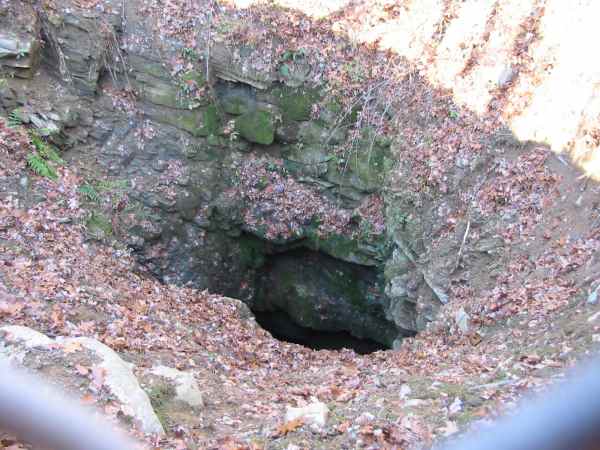
I saw your [Richard Mine Web] pages and enjoyed them, good writeup. The pipe vent that you have in the photo is most likely venting air from the mine. You were probably standing over a capped mine shaft at the point of photographing it. =-O
Also, this picture here on your site, that is the Elizabeth shaft for the Mount Hope mine. It is not 20-40 feet deep, but is in actuality, the deepest dry mine shaft I have discovered in NJ. It is over 300-400 feet deep before it hits water.
I have not searched hard enough for the 2 Richard Mine shafts, but I have maps that know where they are, I know they are capped, and I usually am not very ambitious in finding capped shafts, but I do find open shafts.
Regards, Dan Lopez
In Oct 2007 I got an email from Gerry Stanford in New Jersey, with a follow-up a year later:
Hi Herb -
I found your articles online about the Richard Mine. My great grandfather Frederick Nichols was killed there in shaft #1 in 1902, and two days later 6 other men were killed trying to retrieve his body. I attached the news articles in case you are interested.
I am writing to see if you are aware of the location of shaft #1. I saw the map provided on your site, ( http://retrotechnology.com/iron/mthope/map.jpg ) and the closest I could find was Richard #2, which I assume is talking about the shafts. Based on the articles, I believe workers were trying to get into shaft #1 from #2, so I guess they'd be very close to each other.
Anything you know about this would be appreciated. - Gerry Stanford
I post what I know on my Web site. There are probably some books which discuss the Richard Mine as part of New Jersey lore. They are often written by local historical societies over the years. A search of booksellers for New Jersey based books may find some of them. Or you can contact some of those societies. I encourage you to share your knowledge of the era with them, that's why they exist.
Also, the New Jersey State library, Rutgers University Geology Department, and the NJ Geological Survey are good resources. The NJGS did annual surveys of mines and likely have maps. the early 20th century is the best bet for a time period to review these resources. Google books has digitized some of the oldest books.
Google has digitized most of the 1910 "final report by New Jersey Geological Survey" which has some pages on the Richard mine: check page 400. Here's a Web link to Google's copy of that book. Unfortunately Plate VIII. a map of the Mount Hope mining area, was not digitized properly by Google. Probably their automatic machines failed to scan it, the scanned pages are blank.
"In 1880 ore was being taken through three shafts, of which one (No 7), 160 feet deep, was the southwesternmost one was near the Baker mine. The next to the northeast was No 6, 375 feet deep and the third, (No 3) which was about 500 feet still further northeast, was 400 feet deep. In 1883 the shafts that were active were: No 1, which was to the southwest of No 7 on the vein that was supposed to be the continuation of the Baker vein. About 1,000 feet northeast of this was shaft No 2, and 700 feet further northeast was shaft No. 3."
Item (252) The Richard Mine, pages 400 following, from the Geological Survey of New Jersey, "Iron Mines and Mining in New Jersey" by William S bayley, Volume VII of the Final Report Series of the State Geologist, published 1910.
Finally, the Morris County Park people may have more information, as the site is their park. I hear they have a guided tour of the site from time to time. - Herb Johnson
I sent Gerry this information, and got this reply: "Herb - Thanks for the great info. I'm confident I can find what I need out there somewhere. I'm getting the impression that shaft #1, then, is across the street from #2. The Daily Record - Friday, June 27 news account says the mine collapsed while a train was passing over it. That would indicate to me that it would be southwest of #2 under (or almost under) the tracks, assuming they are the same tracks." Gerry said I could post his name and forward to him any comments that others might send me about his inquiries.
A year later, Gerry wrote: "Last year you posted a link related to a search I was doing for the location of Richard Mine shaft #1. The info you gave me indicated that shaft #1 was about 1000 ft southwest of #2, and the map you referenced showed #2. I used a mapping program to determine where on today's map that location would fall, and I came up with [a] water hole area [which] puts shaft #1 to the South of Richard Mine Rd. The other shafts shown on your map are on the North side." [Note: I'll get measurements from Gerry and add them here.]
"Additionally, I was privileged to meet my first cousin once removed this summer, who rode East with me down Richard Mine Road. As we passed the house pictured in the upper left hand corner of my map link, he stated that when he was a boy there was a field there where the family would have picnics, and relatives would mention that Fred had been killed a bit beyond the field to the south. This would put the mine in the same area as pictured. The blotch of water pictured in the center is what I believe to be the spot, as it is about 980 ft southwest of shaft #2."
"Additionally, Shaft #7 is said to have been southwest of #1, and another large water hole appears in about that location (drag the map to view). To the right of #1 in the picture are some large concrete pillars that appear to have been supports for a road or train tracks. Very strange to see them abandoned out in the woods like that. I'm thinking of taking a walk through there sometime soon to see what can be seen."
"Thanks for your assistance with this!" - Gerry Stanford
Update - In July 2009, someone researching the song "Only A Miner" contacted me about the lyrics which Gerry provided among the newspaper articles. I forwarded the inquiry and Gerry said "Hi Herb - Thanks for passing this along. I will contact [him]. I am planning to take a hike in the woods there sometime this summer as well. With the distances and locations referenced in various maps, some of which you thankfully passed along to me, and some information I gathered from some of the older family members, I think I may be able to locate the location of the particular shaft, or at least come close. Thanks, Gerry."
I recieved another inquiry in Dec 2011 from a descendent of a miner. While I'm waiting for him to confirm I can post his information, I checked around the Web for more information on the Richard Mine and others in the area.
I saw an article "Deep in the Heart of the Highlands" about the Mt. Hope mines in NJ. It was published Spring, 2006 in the "Skylands Visitor Magazine", and written by Mary Jasch. One of the featured persons was Mike Hetman, who has a Web site called "ironminers.com" which includes the Richard Mine among other north NJ mines. I contacted him through his Web site and he replied as follows.
"Thanks for writing. The Richard Mine was worked on a truly massive scale. Unfortunately, there is little but a small number of photos, personal stories, and literature left to remember this important site by. More sad is the fact that portions of the mine complex stood until relatively recent years. The mine connected underground with the Mount Hope Mine and it is through the Richard Mine that the entire complex drains water. We will present historic photos of Richard on the site in the coming months. Please do feel free to link to our site. I wish you an exciting and rewarding journey through New Jersey's mining past! - Mike Hetman of IronMiners
Copyright 2007 Herb Johnson. All rights reserved. Last updated Dec 4 2011.
Contact information:
Copyright © 2011 Herb Johnson